Welcome to Pineville’s Community Mural Projects!
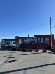
Mural #1 The Postcard of History
The Town of Pineville received a grant from ElectriCities for $10,000 to create a Community Mural in our downtown! The mural was created to represent the Town of Pineville with images of historical significance and artifacts related to the Town! We utilized local muralist, Russ Petty, to help us create this collaborative mural piece.
BUT… Here was the best part!
– We invited ALL Town residents to join us in the painting process! 🎨
– Our Community Mural features “Welcome to Pineville” with each letter containing unique aspects of the Town which YOU and our muralist will painted together!
– About 100 residents joined in the process to help us paint! Thank you to all who helped us!
Stop by anytime to see the Community Mural Project at 330 Main Street, Pineville NC 28134
Detailed Project Proposal (click here)
Have you been wondering what each letter depicts? Find out below!
Located on the side of Kit’s Trackside Crafts, 330 Main St. Pineville NC. This building stood here prior to 1913. Step in and say hi to Kitt, grab a beverage and then feel free to tour the rest of the shops, restaurants, barber shops and stores along the main street.
Train: The old rail depot and a mid-century locomotive representing Pineville’s railway heritage. Engine # 1873 representing the year Pineville was incorporated. Makes for a popular photo op!
P: Early settlers came to the area from the “Great Wagon Road”, made up from Native trading paths beginning in Philadelphia and ending in Augusta. The earliest settlers were Thomas Spratt and his family. Upon reaching the intersection of a Waxhaw Path (modern Lancaster Highway/Polk St) and Catawba path (HWY 51/ Main St.) He made a right turn (the Turnout) and settled in 1761. They were soon followed by the Polk family and many more, whose names are still prevalent in the area. The Historic Polk cabin is a representation of early homesteads of the area and was the birthplace of the 11th president, James K. Polk.
I: The I represents the abundant pine tree groves in the area. Known as Morrow’s Turnout for the David Morrow family who operated a trading post and stagecoach stop here; the area was named Pineville when the railroad built a depot here.
N: The N depicts Miller Brothers Cotton Gin, built 1939. It sat across the street to the right of the mural behind the Pineville Telephone Company. Mule carts full of cotton were lining the streets day and night during cotton season.
E: The E shows the Railway Depot that sat just across the street in what is now the Pineville Telephone Company parking lot. The freight depot sat here, and the passenger Depot sat just across the rails in the corner of the Police Department property. Built in 1852 by the Charlotte, Columbia and Augusta Railway (eventually absorbed into Southern Railway, then Norfolk Southern) the Depot was named Pineville for the pine groves surrounding the area. 1873 is when Pineville was incorporated as a town.
V: The V depicts the town’s water tower, with the Cone Mills water tower and smokestack in the background. Originally the Pineville Cotton Mills, incorporated in 1888, employed most residents and built and owned many of the houses surrounding it. Cone Mills bought the mill in the middle 1940s and continued operation until 1992. The mill property is to the right of the mural, behind where the Cotton Gin was located. The property is now being redeveloped. The masonic lodge was originally chartered as #455 in 1893, until 1931. New charter #759, James K. Polk was chartered in 1983
I: The I depicts the original Charlotte Speedway, built in 1924. The 1.25-mile board track operated for 4 years until maintenance became too expensive. Speeds in the 135 MPH range were recorded, making it one of the fastest tracks in the country at the time. Located in the industrial park .5 mile above town, Industrial Dr. Appears to follow the back stretch of the track, Rodney St. The front stretch, and the curve of the railroad line faintly outlines the footprint of the curves.
L: This L depicts the Pineville Farm Life School Vocational Agriculture School, which sat where the little league ball fields in front of Pineville Elementary School are located.
Built in 1914 it was originally a boarding school, grades 1 to 11. Agriculture and shop classes were the focus for boys in grade 8 to 11, girls took Home Economics. The school was torn down in 1968. The cows depict the Miller Farms, once encompassing most land outside of town. Cotton, corn and livestock were the main products. Their land encompassed what is now the Hospital, the mall, and most everything south to the state line.
L: This L shows the Pineville Lake at Belle Johnston Center, once a private fishing lake. The Jack D. Huges Memorial Park baseball fields are just behind the Police Department and are home to The Pineville Porcupines baseball team. Quilly, their mascots would love you to attend a game! The pool balls represent Bailes Billiard room, a local gathering and gaming shop for over 100 years, located just a few storefronts up on main street. The Pineville Run Club is an active group in the area also and has their logo depicted.
E: This E displays the new Pineville Police Department, diagonally across the street and tracks from the mural.
The Mule: Pineville was once a mule trading hub. The mule lots were located in the grassy lot in the area of College and Church St. Intersection. The throwback team for the Pineville Porcupines, The Jacks, memorialize this. Fun fact: the bricked in doorway where the mule is painted used to be a coal chute into Blankenship Feed and Seed, which occupied this building for many years.
Blakenship Feed: Recognizing Blankenship Feed and Seed, which occupied this building for most of its life.
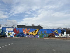 Mural #2 North Carolina State Symbols
The Town of Pineville received a grant from ElectriCities for $5,000 to create another Community Mural in our downtown! The mural represents North Carolina state symbols! We utilized local muralist, Russ Petty, to help us create this collaborative mural piece.
BUT… Here was the best part!
– We invited ALL Town residents to join us in the painting process! 🎨
– About 50 residents joined in the process to help us paint! Thank you to all who helped us!
Stop by anytime to see the mural at 310 Main Street, Pineville NC 28134
State symbols featured: state flower, state bird, state berry, state butterfly, state plant, state turtle, state shell, and state wildflower. Can you identify each aspect?
